E1527-21
ASTM compliant — Phase I exhibits and supporting layers
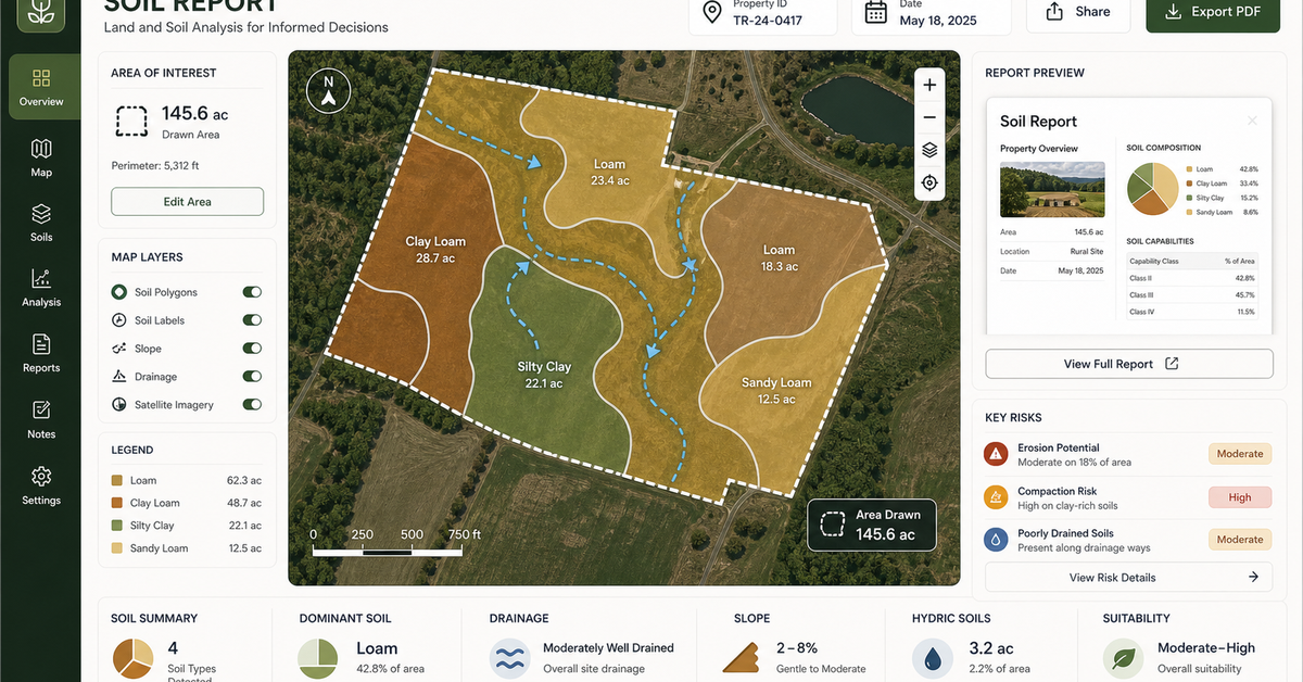
Phase I ESA Support
ASTM E1527-21 compliant assessments with GIS-integrated site analysis.
We help teams turn environmental data into defensible spatial evidence — ranked sites, monitoring dashboards, field-review targets, and briefing-ready maps for Phase I ESA and regulatory work.
ASTM compliant — Phase I exhibits and supporting layers
ASTM E1527-21 compliant assessments with GIS-integrated site analysis.
Spatial analysis of historical land use, underground storage tanks, and release sites.
Priority maps for vulnerable areas with visible evidence, confidence levels, and review boundaries.
Before-after maps and dashboards with automatic change and exception detection.
AOI maps, flight plans, and QA layers that support field teams with export-ready data.
Phase I ESA GIS, environmental site assessment maps, contamination mapping, and regulatory risk mapping.
Buffers, nearby records, site history, adjacent uses, and evidence tables.
Change detection, flood exposure, soil suitability, vegetation, erosion, and land-use shifts.
Maps, evidence notes, source citations, limitations, and exhibit-ready exports.
Bring the closest real workflow. We map what you send, what your team reviews, what evidence stays visible, and what you receive at handoff.
Address, parcel, polygon, site question, required report context, and regulatory concerns.
We map nearby records, soil/site constraints, historical change, flood or environmental context, and limitations.
Each map layer includes source notes, distance/context, caveats, and recommended next check.
Report-ready map packet, evidence table, GIS layer, and scoping recommendation.
Spatial evidence supports due diligence but should not overclaim professional conclusions.
Use wording as Phase I ESA support unless professional-of-record scope is explicitly defined.
Parcel data, USDA soil, EPA/state records, local datasets, historical imagery, flood and environmental layers.
Source citations, buffer logic, limitation notes, and map review.
Report-ready maps, evidence table, PDF-style packet, GIS layers, and next-check list.
No vague discovery phase. You bring four or five things, we return a specific plan you can evaluate.
No open-ended retainers. No "discovery phases" that bill for months without producing anything you can evaluate.
You send the address, parcel ID, or polygon. We confirm the AOI and pull the regulatory framework that applies to the site.
Regulatory database joins (EPA, state UST/LUST, NPL, brownfields), historical land use, plume direction, proximate release sites — all mapped.
ASTM E1527-21 compliant deliverables: Phase I exhibits, GIS layers, contamination overlays, and a written narrative your EPR can sponsor.
If the report is challenged, we stay available — full metadata, processing logs, and source citations are preserved on every deliverable.
These open the real, interactive demos on our main site — not screenshots, not videos. Click around before you decide to talk to us.
No. We provide the GIS-integrated spatial analysis and exhibits that your EP sponsors and signs. Our work strengthens the report; your EP retains professional responsibility.
All 50, with deeper experience in DC, MD, VA, NY, NJ, CA, TX, and FL. State-specific regulatory database integration is part of the project setup.
Standard turnaround is 7-10 business days from site intake. Rush work (3-5 business days) is available with surcharge. Trial- or litigation-ready exhibits with full chain-of-custody documentation typically run 2-3 weeks.
We map the historical land use, identified release sites, regulatory boundaries, and proximate impacts. The spatial evidence supports the EP's risk determination and provides defensible documentation if the assessment is challenged.
Dispatch optimization, container tracking, and demand prediction built for roll-off dumpster companies — runni…
We turn inspections, asset inventories, environmental sampling, construction checks, and field surveys into mo…
Anchored in the NAIPAI pattern: ask aerial, drone, or satellite imagery useful questions, keep confidence and …
We automate spatial workflows for municipalities, utilities, and infrastructure teams — asset inventory, surve…
Address or parcel ID is enough. We will pull regulatory records, historical land use, and proximate release sites live on the call and show you what the spatial analysis surfaces.
Send a site for spatial evidence review